I took a 5,000 nautical mile, 45-flight-hour cross-country trip in a Cessna 177 RG (Cardinal) in August of 2004. You might want to start at part 1, if you haven't already read it.
Unfortunately, in a repeat performance of the week before, a large and ugly front was curving up the length of the East Coast. It was 100 miles from shore and very, very slowly pushing to the east. It might take days to wait for it to pass, and by then there might be another one. So, my plan: try to punch through the front early in the morning, while it was dormant. As soon as the sun started shining, storms were sure to start brewing along the front. But if I could get behind it, into America's Heartland, there was nothing but an enormous high pressure system and perfect, clear weather!
I got to the airport by about 8AM, packed everything back into the plane, and had a long goodbye with Mom and Dad. They were sorry to see me go, and were worried about me doing the entire trip back by myself. My dad, in particular, had so much fun on this epic adventure, he was sad to see me and the plane leave. If he'd had time off from work, he would have come cross-country with me again in a heartbeat. Oh, well... maybe next year.
The only thing I was really worried about was not violating the ADIZ -- the airspace surrounding Washington that is restricted for national security. A violation would give me an up-close view of a plane much faster and more heavily armed than mine. It turns out that while Montgomery Airpark is untowered, the airport has a radio link to the Leesburg Flight Service Station, which actually gives you a takeoff clearance. It's a very unusual procedure for an untowered field. They aren't actually clearing you onto the runway -- you're still responsible for doing that yourself as in any other untowered airport -- but they're giving you clearance to climb into the air under the ADIZ.
As I lifted off into the dull grey, hazy sky, my parents waved goodbye to me from the ground. I waved back, and my trip home officially began!
The first 30 minutes of the flight were spent in some intermittent rain and clouds. It wasn't pretty. But, it was soon obvious that I'd crossed the frontal boundary: the sky suddenly cleared, the wind changed, and the temperature increased. I was now in the high pressure system, and the weather was gorgeous!
45 minutes into the trip I crossed over the Appalachian "Mountains". It's so quaint that out on the East Coast they call these things "mountains." Living in Southern California, it seemed a little silly. Having tangled with the Rockies a week earlier made it downright funny.
My plan was to get to Daviess County Airport in Washington, Indiana. I'd planned on this taking about four and a half hours, which is a pretty long leg for me. One of the skills that I'd honed on the way out was accurately estimating how much fuel I was burning and had remaining. I was now more comfortable with doing longer legs without the fear of running dry. I had a smooth and largely uneventful flight, and landed with 16 gallons remaining -- almost exactly what I'd estimated. (After putting 44 gallons into the plane, the lineman commented, "You're runnin' a little low aren't ya?". I love having the big, 60 gallon tanks.)
Daviess County was a friendly rural airport. There was a small FBO that sold me fuel, but didn't have much food other than a vending machine. The FBO lent me a car, though (I love when they do that!), and a small map to get into town. The first few minutes of the drive were through nothing but cornfields, and everyone I passed on the street gave me a happy wave. People here sure were friendly!
| |
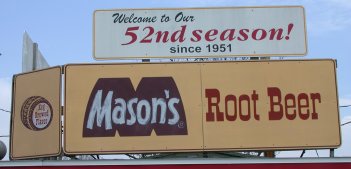
| Mason's Root Beer. I didn't have a camera with me on my trip back, so used this picture I found on the web. Photo copyright Luke W. Cole, www.lukecole.com, used with permission... thanks Luke! |
After my meal, I drove my borrowed car back to the airport and set about my task of deciding on my next destination.
"I don't suppose you have an Internet connection here, do you?" I asked the owner of the FBO, but without much hope of success in the middle of this cornfield.
There was no Internet connection. But, two of the locals hanging out at the airport overheard my question. "Yeah, I need some broadband at home," one said to the other. "My dialup is just too slow for my point-of-sale site that uses 128-bit encryption."
"128-bit encryption." I swear that's what he said. I didn't give the cornfield-dwellers nearly enough credit.
Going west is typically slower than going east. The jet stream blows from the west. The same winds that had been carrying us along at 160 to 170 knots for much of the trip out to New York were now keeping me at a pokey 110 to 120 knots for the return. But, the weather was perfect, and wanted to take as much advantage of it as possible. As I started to cross Kansas I decided to extend the flight by another 45 minutes and changed my destination from Wichita to Ponca City, Oklahoma.
My second flight of the day, like the first, was long and slow but really fun. I was having a great time looking at all the scenery, and the music from Cousin Irv's satellite radio was keeping me revved up. During the morning leg, after a 30 minute search, I'd finally found the "BPM" channel which played dance music perfect for keeping me awake and happy. I had a huge pile of maps and food on the passenger seat with me and was having fun keeping myself stuffed and watching the country scroll past out the window.
I started to wonder: would I possibly have enough energy for a third flight tonight? If only I could get to Dalhart, Texas, I'd be in the perfect spot to get up early the next day and cross the Rockies before the sun got too high in the sky. Ponca City was too far east -- if I spent the night there, I wouldn't reach the high desert until the afternoon, which is exactly the wrong time. Dalhart was two hours past Ponca City, and since I'd already crossed nearly three time zones in one day of flying, I still had a couple hours of light left in the sky. I could probably make it!
I put these thoughts out of my head as I started to descend toward the plains of Oklahoma. After a whole day of flying I'd finally reached the western end of the high-pressure system, and had been in and out of some big, fluffy clouds. But, I was well below them long before my landing in Ponca City, and made a visual approach followed by a near-perfect landing at a very quiet airport in the middle of nowhere.
After I refuelled, I took a look at my charts. Then I started to have second thoughts about Dalhart. This was my first day flying! I wasn't in any rush. Why push? I decided just to spend the night in Ponca City.
I relaxed on the FBO's couches and waited for Gene's Cab Company to take me to one of the hotels in town. Once there, I realized I was completely exhausted and very hungry. I was thrilled to be on the ground and eating a real meal, rather than in the air pushing for Dalhart. I had dinner at the hotel and soon fell fast asleep after hearing something on the news about an unusually strong Monsoonal flow.
I called the front desk. "Can you call a cab for me, please?" I asked, trying to keep the urgency out of my voice.
"Actually, there's already a cab here, sir, should I tell them to wait?"
Perfect! But, there were clothes and laptop accessories everywhere... I hadn't packed yet. "Yes, tell them I'll be there in 10 minutes," I said.
I finished dressing, quickly stuffed everything into my suitcases, and rushed to the front desk. Where I found... no cab waiting.
"Where's the cab?" I asked the man behind the counter. It was just after 6AM. It was already light outside. I could feel the precious early-morning air slipping through my fingers.
"Well, it's rush hour... he's very busy taking people to work and couldn't wait 10 minutes."
"But... but... I'm trying to get to the airport as soon as possible, it's very important." I stammered, with my bags hanging off my shoulders.
He looked at me calmly, and said, "Oh, don't worry. Your flight won't leave for a while yet. Your plane isn't even at the airport. The pilots are the ones in the cab."
A thousand thoughts competed.... What? Where's my plane?? Did someone take it? What flight? What pilot? I'm the pilot. I'm not in a cab. I thought the cab wasn't here. What the heck is he talking about??
"You are taking the flight to Dallas, right?" he asked.
"No. I'm a pilot, I have a plane at the airport and I need to get into the air as soon as possible," I said, visibly annoyed and anxious.
"Oh," he laughed good-naturedly, tranquil as a cat despite my protests. "I thought you were flying to Dallas." It turned out Mesa Airlines has two flights a day to Dallas from Ponca City. One is scheduled for 6AM. The pilots had been at the airport but the incoming plane hadn't arrived, so they'd taken the cab back to the hotel. That, coincidentally, had been the cab I'd almost taken back to the airport.
Of course, I was not the slightest bit interested in hearing this story. I just wanted to be at the airport.
"Is there another cab you can call?" I asked.
"No, there's just the one," he said.
"One cab company?"
He smiled warmly. "You've heard of one-horse towns? This is a one-cab town."
So, yes, there was only one cab company in Ponca City, Oklahoma. In fact, there was only one taxicab in Ponca City, Oklahoma. I suddenly felt like I was in big trouble.
"So, are we talking ten minutes, or, uh, an hour here?" I asked. He just smiled.
I paced in circles for an eternity while that wonderfully cool, smooth air got hotter, thinner, and bumpier. The density altitude was climbing, and visions of that takeoff from Winslow started to dance through my head.
After just a few minutes -- maybe 10 -- the cab showed up with a workman and his lunch box in the passenger seat. The driver dropped the other fellow off at work, then took me to the airport. My nervousness melted away, and I thanked the driver profusely for picking me up so quickly. He drove the cab right up to 97H and helped me put the bags in the baggage compartment.
I was in the air by 7AM. The morning light colored everything a stunning purple. The air was silky-smooth and I slowly climbed up to 11,000 feet for my coming encounter with the higher terrain of the West. As the hours wore on, with music from the BPM channel keeping me energized, I watched the temperature slowly climb 30 degrees. It looked like I'd have to deal with the hot afternoon, one way or another.
The landing in Albuquerque was very challenging. The wind had shifted to 220 degrees, blowing at about 15 knots but their two active runways were 3 and 8! Those runways point to 30 and 80 degrees, respecitvely, which is nowhere near the wind direction. (Pilots always like to land directly into the wind, if possible.)
The controller initially offered me runway 3 but I asked for 8, thinking, "Well, 220-80 is less than 220-30; I guess Rwy 8 is more closely aligned with the wind." A few minutes later, I finally realized the situation: runway 8 was a long crosswind runway, but runway 3 was nearly a direct tailwind runway! For some reason they hadn't yet turned traffic around to use runway 21. Runway 3 was shorter than 8, but had much less crosswind component, making it preferable for me. I switched back to Runway 3 again; the controllers were very accomodating. The big airliners were landing on Runway 8 -- they aren't allowed to land with that much of a tailwind, so had to just deal with the crosswind on the long runway.
I was sweating on final approach. I had never landed with such a gusty, quartering tailwind before, let alone at high altitude! It was 11AM, so the density altitude on the field was more than 7,000 feet. Add the tailwind to the already-thin air, and my GPS groundspeed on final was 125 knots! That's nearly double the normal value. At one point, after getting slightly too high, I found myself descending at over 1200 feet per minute to re-intercept the glide-path -- also nearly double the normal value. My touchdown was a bit firm, but perfectly safe, and I was very proud!
Seeing such a large, international airport again was a change after having spent so much time at untowered fields over the past two weeks. As I taxied to the parking area, I passed a large jet painted with big, friendly letters saying "Planet Airways". Surrounding the jet were three decidedly less-friendly-looking guards wearing cammo gear, holding shotguns, and eyeing me suspiciously as I drove my plane past them. I certainly wasn't in Ponca City any more.
The briefer at Albuqerque Flight Service put an end to that idea pretty quickly. All of the unseasonally dry weather for my trip East was now coming back to bite me for the trip West. I was facing unseasonably moist air, and thunderstorms were blooming all over 5 states. The further we got into the afternoon, the worse it was forecast to get. By the end of a 4-hour flight I'd probably be surrounded by storms everywhere.
I decided to shorten the trip by just going to Flagstaff instead. Hopefully, conditions by then would still be good enough to get in without a problem. I'd have to do one more high-density-altitude landing, but I was getting much better at those, anyway.
I took off from ABQ at about 12:00PM, turned west, and climbed slowly up to 10,500 feet. Other than a gas trip in Lake George, this was the first time since leaving California that I was flying VFR -- that is, under visual flight rules, instead of the much more constrained and protected world of instrument flying. Some of the airways west of ABQ required a minimum altitude of 10,500 feet... but, going west, pilots are required to use even-numbered altitudes. I didn't want to go all the way to 12,000 feet; the performance of the plane up there would be miserable, I'd be on the verge of needing oxygen, and the stronger headwinds would make the trek even slower. I stayed VFR at 10,500' instead.
The trip started out well but turned sour pretty quickly. As the sun climbed overhead at 1PM, the turbulence got almost unbearable. I was having a lot of trouble keeping the plane at altitude; it kept trying to shoot itself up to 11,000 feet and beyond. I slowed the plane down further and further but it didn't seem to help.
Off to my right, perhaps 30 miles to my north, I was keeping my eyes on a line of clouds. They seemed docile at the moment, but they seemed to be building into a menace minute by minute. Ahead of me, to the west, I could see clouds that clearly were already very menancing, but it was hard to tell how far away they were. Is that storm 20 miles away or 200 miles away?
I called the Flight Service Station from the air, asking them about what I was seeing off to my right. "We don't have any convective activity reported there," the briefer said, "but we're having some equipment problems and just might not be seeing it."
Then, something happened that made me even more uncomfortable: the air traffic controllers who'd been watching over me lost radar contact. "Cardinal 97H, we have a radar failure in your area, squawk VFR, frequency change approved." In other words: "Bye. Good luck. We're not watching out for you any more."
At this point I decided I just wanted to be on the ground. There were storms way out ahead of me, storms forming just to my north, turbulence making the trip uncomfortable, and no one on the ground looking out for me while I was in the middle of nowhere. I checked out the map for the nearest place to land. Not much luck there. Airports in the desert are few and far between. Of the airports that existed, most were private or had runways way too short. The rule of thumb is that a runway should be as long as the density altitude is high. The DA was at least 8,000 feet on the ground, but the runways nearby were less than 4,000 feet long.
It seemed that the nearest reasonable alternative was good old Winslow, AZ, our first stop on our trip East the week before. I changed course slightly and tried in vain to relax as the air got bumpier and the storms loomed closer from every direction.
Then, suddenly, out of nowhere... "Cardinal 97H, are you still on frequency?"
It was the flight service station calling!
The Flight Service people are the weather and planning folks (separate from controllers) who I had contacted 20 minutes earlier to ask about the storms. Afterward, I had left the radio tuned to their frequency, and forogtten about it. Now, they were calling me back!
Having Flight Service call you is very unusual. It's sort of like calling Information to get someone's phone number, and 20 minutes later, the operator calls you back to tell you that they found additional information and thought you might need it. This had nothing short of a miraculous effect on my mood. It felt great to know that there was someone watching out for me.
"Yes, 97H we're still here, go ahead!" I replied, enthusiastically.
"Oh, good, I just saw some convective activity pop up on my radar, I think it's what you were asking about before," he said. He described the weather and which direction it was moving and we discussed various options for my landing. Suddenly, I felt so much better!
I finally decided to land in Holbrook, AZ -- an airport just a few minutes (20 miles) closer to me than Winslow. Those menacing clouds to the north no longer seemed like a factor, but the clouds way out ahead, to the west, were pretty scary. The guy at Flight Service kept assuring me that Winslow was clear, but I wanted to be on the ground without further delay.
Approaching Holbrook, I tuned to the airport radio frequency, and tried to contact someone on the ground with no luck. The airport didn't have a control tower, but I was at least hoping someone could advise me which runway was being used and what the wind looked like. I got no response and suddenly felt very alone again.
As I approached, it became clear which of the two runways I should use -- one of them was a 7,000' piece of concrete, and the other was 4,000' of dirt. I circled the airport once to get a good feel for which way the wind was blowing and to ensure that the runway was safe, then brought '97H in for a picture-perfect greaser of a landing. As usual for these high-altitude airports, the landing was quite fast, but I felt like the king of the world as the plane gently bled off speed and rolled toward the end of the runway. I was so happy and proud to be safely on the ground!
I parked the plane, called my mom to let her know I was OK, then and looked around for any signs of life. There were none. The flight office was unlocked, so I wandered in and looked around at the stacks of aviation memorabilia and charts everywhere. A 20-year-old TV was in the corner near a tattered couch. But not one person was anywhere on the airport, and the place felt like a ghost town, right out of an old Western. This was of little concern to me as I lay down on a couch and enjoyed being stationary.
I'd been relaxing in Holbrook for about 30 minutes when I heard a plane pull up outside. A man walked into the lounge.
"Hey, is that your Cardinal outside?" he asked.
"It sure is," I said.
And that's how it started: a 3-hour conversation during which I increased my knowledge about thunderstorm flying ten-fold from a pilot named Steve.
Steve was born a pilot, flying since an age that most of us are learning to drive. He'd spent most of his life around Arizona and New Mexico, so flying in the high desert came naturally to him. He was now a professional charter pilot and flight instructor, and had a few hours to kill while waiting for a passenger to show up for a 5PM run down to Phoenix.
When he asked me why I was there, I told him of my adventures with turbulence and storms closing in around me, feeling as if I had somehow cheated death. He laughed good-naturedly, pointed up to a small gap in the clouds that were now looming even closer, and said, "I'd tell any one of my students that he could drive right up to those clouds and poke his head in, and just turn around if it looks ugly."
"Drive up to those??" I asked, aghast at his suggestion that any pilot, let alone a student, should fly into such menacing weather.
Why, yes, Steve patiently explained, your plane goes 10 times as fast as a storm, and as long as you have an escape route, there's no harm in weaving your way through a single line of storms.
For an hour, he stood with me on the tarmac, pointing at the swirling weather that was visible from the airport in every direction. North, south, east, and west, and everything in between... anyplace we looked, the weather was different. Somewhere in the sky, a storm was gathering, or dissipating; clouds were building, or disappearing; rain was starting, or stopping, or generating lightning, or not. He pointed everything out to me, describing what was dangerous, and what wasn't; what I could fly close to, and what I shouldn't. Those clouds indicate turbulence; those don't. That looks like trouble; that doesn't. He related what we were seeing outside to what we were seeing on the weather radar and what we would see if we were in the cockpit. Eventually, a thunderstorm passed directly over the airport, and he described every stage of it to me in detail as we were watching. It was the most incrdible, up-close-and-personal lesson in thunderstorms I could imagine.
By the end, I felt energized, I felt armed with knowledge, and I felt like I could get right back in the plane and easily navigate my way to Lake Havasu. Steve thought I could, too. But it was getting late, and tomorrow morning, I'd get another chance.
Finally, Steve's passenger arrived at the airport. I bid him a fond goodbye, in awe of his incredible ocean of knowledge, and my own luck at having met him. He wished me well and head out, passenger in tow. I watched my new friend's plane disappear into the distance, contemplating that his passenger couldn't possibly realize just how safe she was under his expert care.
Just then, a new wave of exhaustion and hunger hit me. I borrowed one of the airport's crew cars, found some dinner at a Mexican restaurant, and soon fell into a deep sleep at a hotel near the airport.
My game plan for today: finish my desert crossing as early in the morning as possible. I was now firmly resolved never to fly across the high desert in the afternoon again! The turbulence was just too tiring. I peeked behind the window shade and saw the sky was still pitch black -- for once, I had plenty of time!
I took a nice long shower, watched the weather channel, and called Flight Service. This unusually moist and unstable air was still with me, and there was supposed to be some intense and widespread thunderstorm activity once the sun started to add energy to an already unstable situation. I was happy to be up so early!
It was now 4:45AM. The sun had been rising at about 6AM local time every day, so I should have been fine getting to the airport by about 5:30. At least, that's what I thought to myself as I took another peek out the window....
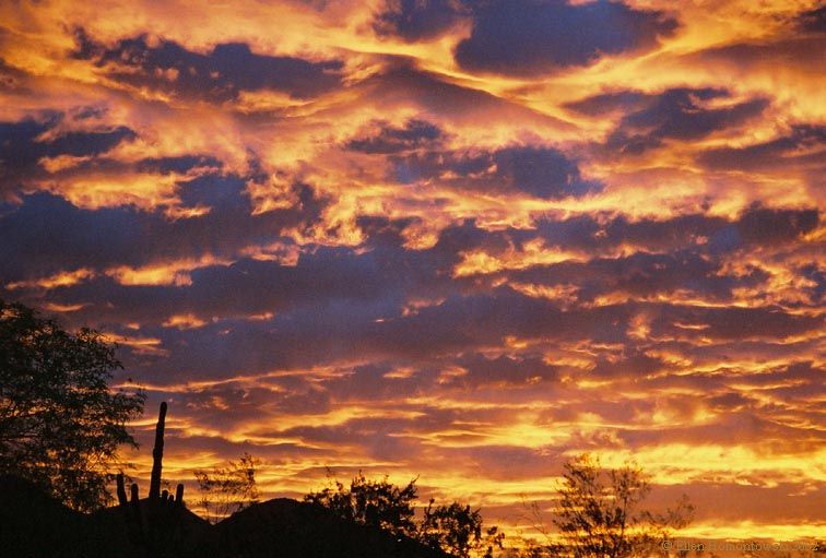 |
| I didn't have a camera with me on the westbound leg of my trip, but the sunrise in Holbrook looked something like this photo I found on the web at hikingallery.com. |
... only to see a beautiful, early-morning desert sunrise starting! NOOOOO!!!!!!!!!!!! Damn it, Arizona, why can't you use Daylight Savings Time like everyone else, instead of messing me up and making me an hour late for the sunrise!??!
I threw all my clothes into a suitcase, raced to the checkout counter, and sped the short distance back to the airport in my borrowed car. I was there by 5 and after a quick but thorough pre-flight inspection managed to get into the air by about 5:20. The sky was a beautiful, deep purple, with orange and red streaks. Moments after the wheels left the ground, the edge of the sun started to show around the peaks of a nearby mountain range.
It was beautiful.
The plane seemed to glide along as if it didn't even need me there to control it. The air was silky smooth, the temperature was cool and pleasant, the music was inspiring, and the scenery was simply breathtaking. Passing over Sedona, with its vibrant colors intesified by the early morning light, was... well, it brought tears to my eyes, and I simply can't describe it. Sorry, but, you'll just have to do your own cross-country trip and see it for yourself.
The mountains that surround the Los Angeles basin limit the number of convenient routes in from the desert. One good way is to fly through the Banning Pass, east of the city; another is to approach from the north, and fly through the passes near Palmdale.
My plan had been to fly west until Needles, then turn to the
southwest and stop at Palm Springs for fuel, and finally fly another
westward leg through the Banning Pass and homeward (see map at right
-- blue route).
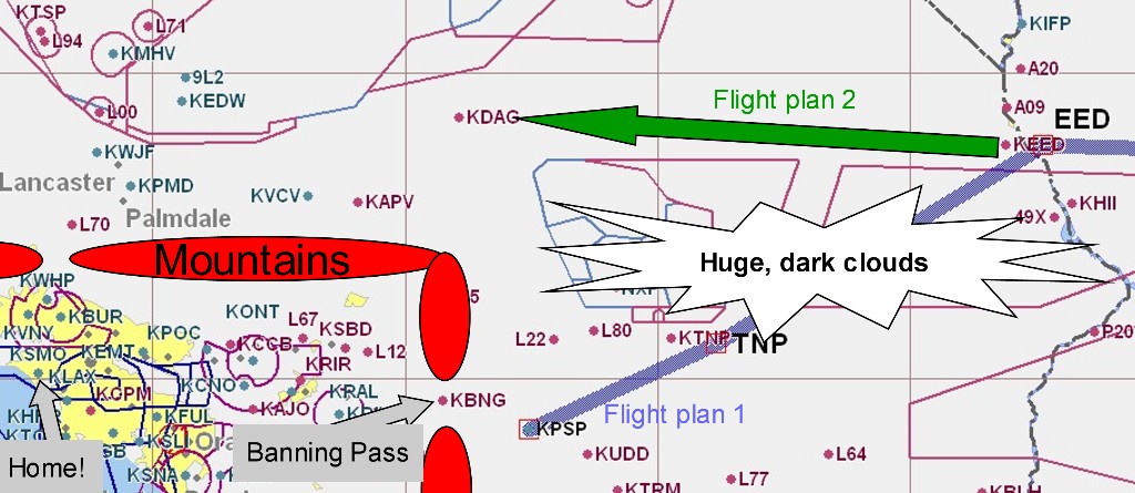
Throughout the morning I'd been following Steve's advice, making some slight deviations to avoid turbulent air, as evidenced by billowing cumulus clouds above. Now, approaching Needles, his advice to me got its first serious test: there was a huge, grey cloud mass to my left, exactly in the area where I wanted to turn. It definitely looked like something not to be flown through.
"No problem," I thought, remembering my lessons. "I'll just keep 10 miles away from it, and keep flying until I find a space where I can fly south." But I kept flying further and further west, and it soon seemed like that simply enormous cloud mass went all the way to the mountains.
Time for Plan B. I pulled out my sectional chart to see what airports were available, and did what Steve said I should -- just look out the window and trust my eyes. To the south was a boiling cauldron, but straight ahead, to the west, everything looked beautiful. So Plan B was to just keep going straight, land at Dagget airport for fuel, then head further west until reaching the mountain pass near Palmdale (see map at right -- green route).
I dialed up Flight Service to see what they had to say about my plan. They had their hands full with pilots both reporting and inquiring about the bad weather all around us. When it was finally my turn, I told them my situation.
"We're about one-zero miles west of Needles, our original plan was to turn south toward Palm Springs and then head through the Banning Pass, but now it looks like continuing west toward Dagget is a better plan. Do you concur?"
"Uh.. yeah, that definitely looks like a better idea." the briefer told me over the radio. He noted that there was one possible problem area -- a small cell of light to moderate rain just before (east of) Dagget. But, it looked possible just to deviate slightly to the south to get around it.
I decided that Plan B looked good. I was flying VFR, but getting "flight following" from controllers. That is, I was talking to them, and they were watching me on radar, but I was not getting the protections and privledges of flying IFR. I notified the controllers that I was going to be diverting from Palm Springs to Dagget, and also continued to monitor the Flight Service frequency on my second radio.
Plan B continued to look good... for about 20 minutes. Then, the Flight Service station called me (good thing I'd been monitoring them!) and gave me the bad news that the "light-to-moderate" rain near Dagget had developed into a thunderstorm cell. It was also moving slowly to the north-east, and had moved virtually right over the airport! Uh oh.
I took another long look at the chart. There were a few possibilities. One was to turn around and land near Needles. But, no, Steve would have none of that -- There's nothing wrong with poking your head into there and turning around if you don't like what you see, his words echoed in my head. So I hatched Plan C: continue west, with just a slight course adjustment southward -- hopefully enough to squeak past the thunderstorm cell, but not too much to put me into the restricted military airspace five miles south of Dagget. Then, I'd land at Apple Valley Airport which was a few miles southwest of Dagget and clear of storms. If things started to look ugly, I had enough room and fuel to retreat back to Needles.
Unfortunately, Plan C would put me in between a restricted-airspace rock and a thunderstorm hard place (see map at right). Would I have tried this maneuver even 24 hours earlier? Not a chance. But armed with the knowledge that Steve had imparted, I was confident that I could try this experiment safely, with plenty of ways to escape if it went bad.
I certainly had my hands full, though. I was listening to the busy Joshua Approach Control frequency on one radio, and the almost-as-busy Flight Service frequency on the other. There were constant conversations on both frequencies about the position of various storm cells, and I was trying to listen to both, while avoiding the restricted airspace and (unsuccessfully) trying to get permission to enter it. Oh, and flying the plane.
If you're not a pilot, it's hard to describe this situation, or how much concentration it requires.
Cardinal niner seven hotel, that storm cell seems to be directly over
Dagget airport now
Roger, we're going to try for Apple Valley instead; do you think
there's room to fly in between the storm and the restricted airspace, uh,
R-2501?
Niner seven hotel, uh... I'm not sure, I don't have the airspace
boundaries on my weather display ... if you're talking to Approach you
might want to ask them if you can get in there, though
Oh, that's a great idea -- I'm going off frequency to ask them,
thank you!
[Push Com 1 button] Joshua Approach, Cardinal niner seven hotel,
we're trying to stay as far south as possible for weather, is there
any way we can get into R-2501?
Cardinal niner seven hotel, uh... negative, I wish I could but it's
hot today
He sounded genuinely apologetic.
Niner seven hotel roger, uh, we're going to stay as close to the
border as we can using the GPS Joshua approach, falcon jet five niner foxtrot, pirep for you it
looks like there's a huge cell over palm springs, uh, about 8 miles
across and moving north
Roger
piper two seven niner contact los angeles
los angeles flightwatch, cessna six niner charlie, that storm near dagget
center now, frequency one three four point niner five
seems to be about two miles northwest of the airport now
one three four point niner five for two seven niner, good day
and moving slowly, maybe, 10 knots north west
joshua approach execjet two four eight with you, niner thousand
execjet two four eight, joshua approach roger
cessna six niner charlie, los angeles radio roger, thank you for
cardinal niner seven hotel contact joshua approach now on one two four
point eight
the pirep, break, cardinal niner seven hotel are you still on frequency?
[Push Com 2 button] Cardinal niner seven hotel Affirmative, standby
[Push Com 1 button] Cardinal Niner Seven Hotel say frequency again?
Cardinal Niner Seven Hotel, frequency one two four point eight
One Two Four point Eight for niner seven hotel, Thank you, so long
[Push Com 2 button] Los Angeles FlightWatch, Cardinal niner seven
hotel go ahead
Cardinal niner seven hotel did you copy that pirep
... and so on like this. I was approaching a large grey storm mass. Visibility was dropping. There was blue sky 20 degrees to the left, which I desperately wanted to fly into, but this confounded restricted airspace was in the way! I zoomed the GPS all the way in so that it showed nothing but my airplane and the boundary of the R-2501, a vertical line to my left. I was flying as close to the boundary as I could while still leaving enough room to make a 180-degree turn in case I got too close to the storm.
Between working both radios, watching the GPS, watching the storm, and flying the plane, I felt like I was using 100% of my brain. If you had asked me what day it was, I could not have told you.
Wait... is that blue sky I can see behind the cloud? Steve said that means the air in that direction is safe. Quick bump -- is that the high frequency vibration Steve said indicates I'm too close to the storm cell? Uh oh -- a quick, heavy burst of fine raindrops -- was there any hail?
My eyes were glued to the GPS. Where's the end of this damned restricted area!?
Finally -- it happened! At the top of the screen, the end of R-2501 appeared. The storm was still a few miles ahead and to my right. As the seconds ticked by, the airspace boundary got closer and closer, until I reached it at last, and turned safely away from the weather. I'd done it!!
I was euphoric, and suddenly very relaxed, as Apple Valley came into view. I started my descent, feeling like I was on top of the universe. I had, at that moment, just as much a feeling of pride and accomplishment as the day I'd received my pilot's license -- an event, ironically, that happened only 3,000 feet below me.
Back then, it had seemed more like a friend's backyard than an airport. The flight school was in what looked to be someone's basement, complete with bookshelves full of old magazines, racks of airplane parts, and a cat sleeping on the couch by the window. I'd never been to Apple Valley before taking my test, and hadn't been back since. I'd later wondered if Apple Valley was really as I'd remembered, or if I was just romanticizing that magical place where I'd earned my wings.
After landing, I taxied around for a while, looking for some sign of life. Apple Valley airport pretty big for a sleepy-town field. I finally found what seemed to be the transient parking area and shut the plane down. A few hundred feet away, one of the airplane hangars was open, so I moseyed on over to see if I could find someone who would sell me fuel. (I would normally walk, but being in the Mohave Desert it seemed more appropriate to mosey.)
As I got closer I saw three old war-birds in the hangar: one disassembled airplane and two men sitting in their chairs and watching all the young whipper-snappers try to learn to fly. At their feet were two cats, looking lazy in the way that only cats can. It was exactly the picture you'd get if you asked Norman Rockwell to draw a rural airport.
The two of them eyed me as I approached. "Hi," I said at last, trying to hide my smile -- Apple Valley was, in fact, exactly as I'd remembered it. "Do you guys know where I can buy some fuel?"
"Oh, sure, you just gotta find Dusty. Dusty'll get you all squared away."
Just then, a fuel truck came 'round the corner, driven by a man who looked like he could easily be Dusty. He asked me how much fuel I wanted. "Oh, just up to the tabs," I said, trying to resist an urge to forget the fuel and spend the rest of the day playing with the cats.
While Dusty brought '97H up to two-thirds fuel, I called the Flight Service Station check on my prospects for getting home. There were three problems. First, the marine layer hadn't quite broken up over Santa Monica, so it looked like I'd need to file IFR once I got closer to landing. Second, President Bush was supposed to be visiting Santa Monica that morning, creating a temporary no-fly-zone over the city. Busting through a "Presidental TFR" (Temporary Flight Restriction), even if you're on an IFR flight plan, is an excellent way to lose your license (courtesy of the FAA) or even your life (courtesy of an F-16). Bush was supposed to be gone by 9AM, and sure enough, the briefer told me that TFR was no longer active.
The third problem was that there were still thunderstorms all over Southern California. The briefer gave me all the required and alarming-sounding news: thunderstorms to the south, north, and east. Even 24 hours earlier, hearing this would likely have made me hide under the bed. But, now, thanks to Steve, I knew it wasn't a problem -- I was standing outside and could clearly see all the thunderstorms and the paths around them. The western sky was perfectly clear, and that's where I wanted to go. No problem there. The storms to the north didn't bother me, since I'd just come through there successfully, and they were all moving further north anyway. The only slight problem was that there was a large, menacing cloud about 20 miles south of the airport, with a runway that points south. It was very slowly moving closer and looked like it might develop into a thunderstorm given more time. So, my plan was to take off to the south, as soon as possible, and immediately turn west into the clear skies.
At about 9:30, I started the plane up again and started the long taxi back to the north end of the north/south runway. The airport had awakened; a half-dozen planes were now getting ready to take off or land. One plane struggled to take off -- trying to lift off, settling back down to the ground, and trying to lift off again. After bouncing down three-quarters of the runway, the plane finally became airborne. A smile crossed my face as I remembered how many high-density-altitude takeoffs I'd done in the past week, and how much better at them I'd become.
It was finally my turn. I accelerated down the runway until Vr+15 and authoritatively lifted off. A minute later and 800 feet higher, I turned to the west, away from all the storms and towards home sweet home. I guided the plane up to 8,500' and aimed for Palmdale. It was still early enough in the morning that the air was very smooth.
Using my second radio (it's so much easier to have two radios!), I tuned in to the airport information frequency: Santa Monica Airport information Foxtrot, time 1851 zulu. Wind 220 at 7, visibility 5.... Wow! It's one thing to see home on the map, but actually hearing a radio transmission from the airport was very, very cool. I was getting so close!
I started my descent after the Falcon jet that I never actually saw. Passing directly over Burbank airport, I could see the valley was quite hazy -- I'd forgotten about LA's smog. Just as I started to worry I might lose the 3 miles of visibility legally required for visual flight rules, my IFR clearance was finally issued. Then, moments later...
Cardinal 97H, 3 miles from BEVEY, turn right heading 180, maintain 3,000 'till established, cleared for the approach -- the exact words I'd heard during dozens of previous instrument approaches into Santa Monica, I could have recited them from memory. But this time, hearing those instructions were hard to believe. I couldn't believe I was actually back home. I repeated the instructions back to the controller and started to remember that incredible approach to Ticonderoga. Similar feelings of excitement started to well up inside me until I realized that I'd intercepted the final approach course and still had work to do.
A minute later, SoCal Approach called me again: Cardinal 97H contact Santa Monica tower now, 120.1, good day. I said goodbye, hit the button to change frequencies, keyed the mic, and said:
"Santa Mon..."
... and my voice cracked. I started to get teary-eyed. Here I was, trying to be a professional-sounding pilot, and suddenly was so overwhelmed by the emotion of being back home that I'd choked up and literally couldn't get the words out of my mouth. I'd been fine until I'd actually had to say the words "Santa Monica". How embarassing.
I quickly regained my composure, cleared my throat and tried again. This time it worked: "Santa Monica tower, Cardinal 1597H is a mile outside BEVEY...". I had an almost uncontrollable urge to add "...and it's SO GREAT TO BE HOME!". I resisted.
"Cardinal 97H, good morning, continue on the approach, please keep your speed up as much as possible," I was told. I recognized the controller's voice, which reinforced the feeling that I was finally home! Keep my speed up? That's all? Don't you want to comment on what a monumental event this landing is???
I saw the runway ahead of me through the smog, right where it was supposed to be. It looked... smaller.
At the risk of making a way-too-geeky analogy: Frodo Baggins was once living a sheltered life in the Shire. He went on 1,000 pages of worldly adventure, and at the end, came back to the Shire. Somehow, it seemed quaint to him... smaller in the light of all the experience he'd been through. That's how I felt.
My pontificating was interrupted by the controller. She was pointing out 4 other airplanes trying to land at the same time, and asked, "Cardinal 97H, can you increase your airspeed by 10 knots?". What? I'm already doing 100! Ah, lovely Santa Monica. At what other municipal airport can a single-engine Cessna expect to receive an instruction to blast down a 2-mile final at 110 knots indicated? Ha ha, I'm definitely home!
Half a mile from the runway, I finally brought the plane to a screeching halt, from 110 knots down to 65, and made an entirely respectable landing. I pulled off the runway and just started laughing hysterically. It was just too cool to be back there again.
I taxied over to my parking space -- not just a random space at a random airport, but my parking space. I shut the plane down one final time, opened the door, and called my parents.
Wow.
Planning a trip like this of your own? Check out my tips for pilots.
Jeremy Elson, August 2004